Importance of Ladakh
- 03 Jul 2020
- 12 min read
Why in News?
Recently, twenty Indian Army personnel, including the Commanding Officer lost their lives at the hands of Chinese troops in the Galwan Valley of Ladakh.
Introduction
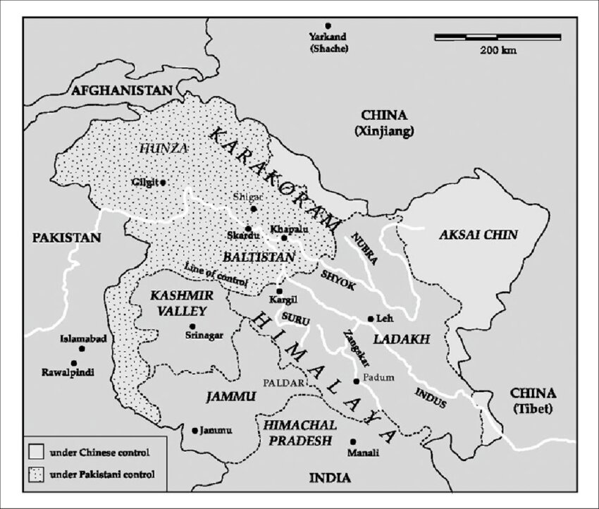
- Ladakh is also known as “the Land of Passes‟ (La-passes, dakh-land) is the largest in area among the regions viz., Jammu, Kashmir and Ladakh with an area of 95,876 km2. The region is administered by India as a union territory.
- Bordering regions: It is bordered by the Chinese Tibet Autonomous Region to the east, the Indian state of Himachal Pradesh to the south, both the Indian union territory of Jammu and Kashmir and the Pakistan-administered Gilgit-Baltistan to the west, and the southwest corner of Xinjiang across the Karakoram Pass in the far north.
- River system: The Indus River and its major tributaries, the Shyok-Nubra, Chang Chenmo, Hanle, Zanskar, and Suru-dras rivers, drain the region. Glacio-fluvial processes aided by freeze- thaw weathering have formed the high altitude landscape of Ladakh.
- Climate: Ladakh has an extremely harsh environment and one of the highest and driest inhabited places on earth. Ladakh’s climate is referred to as a “cold desert” climate due to its combined features of arctic and desert climates.
- The entire area is nearly devoid of vegetation with the exception of valley floors and irrigated areas, due to the following factors:
- These include wide diurnal and seasonal fluctuations in temperature, from -40°C in winter to +35°C in summer, and extremely low precipitation, with an annual 10 cm to 30 cm primarily from snow.
- Due to high altitude and low humidity, the radiation level is amongst the highest in the world.
- The entire area is nearly devoid of vegetation with the exception of valley floors and irrigated areas, due to the following factors:
- Soil type: In Ladakh soils range from gravely and sandy loams on the alluvial fans to sandy and silt clay loams on the flood plains of Indus. Ladakh’s soil is described as skeletal, calcareous with an alkaline reaction.
- By and large, soil is coarse and sandy, having varying quantities of pebbles. The soils are characterized by low organic matter content and poor water retention capacity.
History of Ladakh
- Dogras invasion: Historically, Ladakh was an independent kingdom from about A.D. 950 until 1834, when Hindu Dogras (from Jammu, which is southwest of Ladakh) invaded it.
- The Sikhs acquired Kashmir in 1819, Emperor Ranjit Singh turned his ambition towards Ladakh. But it was Gulab Singh, the Dogra feudatory of the Sikhs in Jammu, who went ahead with the task of integrating Ladakh into Jammu and Kashmir.
- Tibet invasion: In May 1841, Tibet under the Qing dynasty of China invaded Ladakh with the hope of adding it to the imperial Chinese dominions, leading to the Sino-Sikh war.
- However, the Sino-Tibetan army was defeated, and the ‘Treaty of Chushul’ was signed that agreed on no further transgressions or interference in the other country’s frontiers.
- British suzerainty: After the first Anglo-Sikh war of 1845-46, the state of Jammu and Kashmir, including Ladakh, was taken out of the Sikh empire and brought under British suzerainty.
- As a buffer zone: The state of Jammu and Kashmir was essentially a British creation, formed as a buffer zone where they could meet the Russians.
- Consequently, there was an attempt to delimit what exactly was Ladakh and the extent of the state of Jammu and Kashmir, but it became convoluted since that area came under Tibetan and Central Asian influence.
- Pakistan and China border dispute: Ladakh became a contested territory between the newly independent nations of India and Pakistan. In the early 1960’s a substantial area of eastern Ladakh was annexed by China.
- Due to increasing tensions between India and Pakistan, the Chinese invasion of Tibet in the 1950s, and their occupation of the Aksai Chin region in 1962, Ladakh has become one of India’s most important strategic zones.
- Strategic location and border disputes with Pakistan and China have assured a firm foothold for army presence since the past 50 years
Importance of Ladakh
The importance of Ladakh to both India and China is rooted in complicated historical processes that led to the territory becoming union territory in 2019 (earlier it was part of the state of Jammu and Kashmir), and China’s interest in it post the occupation of Tibet in 1950.
- Rich in natural resources: Ladakh is situated within the upper reaches of the Indus watershed, which in total supports about 120 million people in India (in the states of Haryana, Himachal Pradesh, Jammu & Kashmir, Punjab and Rajasthan) and about 93 million in the Pakistan province of the Punjab (literally, “Land of the Five Rivers”).
- Careful management of water resources within Ladakh is therefore vitally important, not only for the livelihoods of Ladakhis and the ecosystems of Ladakh, but for the health of the whole river system.
- Solar radiation: It is one of the most abundant natural resources in Ladakh, with annual solar radiation exceeding averages for other areas of India with high insulation.
- Geothermal potential: surveys have identified a geothermal resource at depths suitable for exploration and development.
- This resource could be developed to provide grid connected power to small settlements and army bases sited on the national highway.
- Tourism industry: Popularly known as the Lama Land or little Tibet, Ladakh lies at altitudes ranging between about 9,000 feet and 25,170 feet. From trekking and mountaineering to Buddhist tours of various monasteries, Ladakh has it all.
- Provides connectivity: The passes of Ladakh region connect some of the politically and economically significant zones of the world like Central Asia, South Asia, China and the Middle East.
- Market access: The south Asian countries can reach Central Asian markets through this region. Countries like Uzbekistan, Turkmenistan and Kazakhstan are rich in uranium, cotton, oil and gas resources.
- Energy security: In future, the oil and gas pipeline from Iran to China can pass through this mountainous corridor. India‟s energy needs can also be met by constructing a pipeline from Central Asia via this region.
Other Significance
- Geopolitical Significance: The land of Ladakh enjoys the significance of being located at the ancient Silk Route which passes through these regions and played a very vital role in the development of culture, religion, philosophy, trade and commerce in the past.
- Geostrategic location: The presence of resources is what makes India, China and Pakistan struggle over Ladakh, in order to gain control over resources in this region. Pakistan and China are in conflict with India over Siachen and Aksai chin in this region. Ladakh’s geostrategic significance has increased in the backdrop of these conflicts.
India-China Border Dispute
- The origins of this contention date back to the British Raj which failed to demarcate the border between its colony and China definitively.
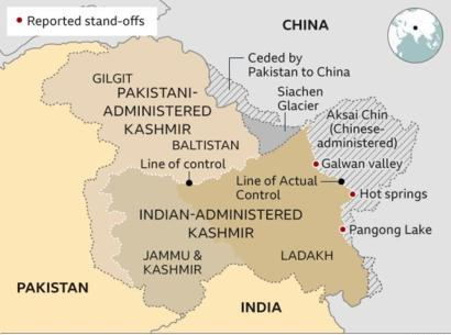
- Recently, Indian and Chinese armies are engaged in the standoff in Pangong Tso, Galwan Valley, Demchok and Daulat Beg Oldie in eastern Ladakh.
- The Galwan Valley area comes under Sub Sector North (SSN), which lies just to the east of the Siachen glacier and is the only point that provides direct access to Aksai Chin from India.
- Both countries are rising nations which share a 3800 kilometre long border of which a large part remains disputed.
- By and large, today‟s border issue revolves around two main boundary designs that have been put forward by the British.
- India continues to maintain the McMahon Line as the legal border, while China has never accepted the border, stating that Tibet was never independent.
- In 1962, Chinese troops crossed the McMahon line and, after war, China pushed forward to establish a “Line of Actual Control”.
- However, none of these boundaries had ever been anchored in a binding bilateral treaty. And so, the status of the Indo-Chinese border in the western section at the time of Indian independence remained unsolved.
- By and large, today‟s border issue revolves around two main boundary designs that have been put forward by the British.
Line of Actual Control (LAC)
- The LAC is the demarcation that separates Indian-controlled territory from Chinese-controlled territory. India considers the LAC to be 3,488 km long, while the Chinese consider it to be only around 2,000 km.
- The India-China LAC in Ladakh is an outcome of the territory illegally retained by China after the 1962 conflict. The Chinese occupation of parts of Aksai Chin is not supported by historical or legal documents.
- It is divided into three sectors:
- the eastern sector which spans Arunachal Pradesh and Sikkim
- the middle sector in Uttarakhand and Himachal Pradesh
- the western sector in Ladakh
Conclusion
- Ladakh has the potential to act as a vessel to feed India its required energy resources. For this peace in Ladakh is a condition. For peace, equal unbiased development is mandatory.
- Therefore, India’s policymakers, while drafting their policies for Ladakh, should consider its geographic location, fragile environment, resource potentials and its people’s aspirations. In such a strategic location, it is crucial to keep all these aspects in harmony to take advantage of it to its fullest.


